Waihona:Map of Japan with highlight on 47 Okinawa prefecture.svg

Size of this PNG preview of this SVG file: 600 × 600 mau pikela. Other resolutions: 240 × 240 mau pikela | 480 × 480 mau pikela | 768 × 768 mau pikela | 1,024 × 1,024 mau pikela | 2,048 × 2,048 mau pikela.
Waihona kumu (Waihona SVG, 1,024 x 1,024 mau pikela, nui waihona: 15 KB)
| Description |
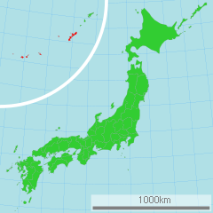
日本語: 沖縄県の位置図
English: Map of Japan with highlight on Okinawa-ken |
||||||||
| Source | 国土交通省 国土数値情報(行政区域) | ||||||||
| Author | Lincun | ||||||||
| Permission (Reusing this file) |
|

other versions
 |
File:Map_of_Japan_with_47_Okinawa_prefecture.svg
|
 |
File:Map_of_Japan_with_47_Okinawa_prefecture_zoom.svg
|
derivative works
Derivative works of this file: RuptureAreasNankaiMegathrust.png
Original upload log
| date/time | username | resolution | size | edit summary |
|---|---|---|---|---|
| 16:49, 2 March 2007 | User:Lincun | 1,024×1,024 | 15 KB | <span class="comment">({{都道府県地図情報 |都道府県=沖縄県 |都道府県Latin=Okinawa-ken }} )</span> |
Mōʻaukala waihona
Kāomi ma ka lā/hola no ka nānā ʻana i ka waihona ma kēlā manawa.
| Lā/Hola | Kiʻiliʻi | Nā Nui | Mea ho‘ohana | Kaumanaʻo | |
|---|---|---|---|---|---|
| okamanawa | 00:55, 16 Malaki 2011 | | 1,024 × 1,024 (15 KB) | TAKASUGI Shinji | color changes for a better contrast: lightgreen → limegreen deeppink → red |
| 02:22, 21 'Apelila 2008 |  | 1,024 × 1,024 (15 KB) | BetacommandBot | move approved by: User:LERK This image was moved from Image:Map of Japan with highlight on 47 Okinawa 沖縄県.svg {{User:Lincun/都道府県地図情報 |都道府県=沖縄県 |都道府県Latin=Okinawa-ken }} [[Category:Maps of Okinawa pr |
Nā Hana waihona
Loulou kekahi ‘ao‘ao i kēia waihona:
Global file usage
The following other wikis use this file:
- Usage on ace.wikipedia.org
- Usage on bat-smg.wikipedia.org
- Usage on bcl.wikipedia.org
- Usage on ca.wikipedia.org
- Usage on cy.wikipedia.org
- Usage on de.wikipedia.org
- Usage on en.wikipedia.org
- Usage on eo.wikipedia.org
- Usage on es.wikipedia.org
- Usage on fa.wikipedia.org
- Usage on fi.wikipedia.org
- Usage on fo.wikipedia.org
- Usage on fr.wikipedia.org
- Usage on hi.wikipedia.org
- Usage on hr.wikipedia.org
- Usage on id.wikipedia.org
- Usage on ilo.wikipedia.org
- Usage on it.wikipedia.org
- Usage on ja.wikipedia.org
- Usage on jv.wikipedia.org
- Usage on ko.wikipedia.org
- Usage on lt.wikipedia.org
- Usage on mk.wikipedia.org
- Usage on mr.wikipedia.org
- Usage on ms.wikipedia.org
- Usage on ne.wikipedia.org
- Usage on nl.wikipedia.org
- Usage on no.wikipedia.org
- Usage on pl.wikipedia.org
- Usage on pnb.wikipedia.org
- Usage on pt.wiktionary.org
- Usage on ru.wikipedia.org
- Usage on sah.wikipedia.org
- Usage on sco.wikipedia.org
- Usage on sh.wikipedia.org
- Usage on sr.wikipedia.org
- Usage on su.wikipedia.org
- Usage on sw.wikipedia.org
- Usage on tl.wikipedia.org
- Usage on tr.wikipedia.org
View more global usage of this file.